


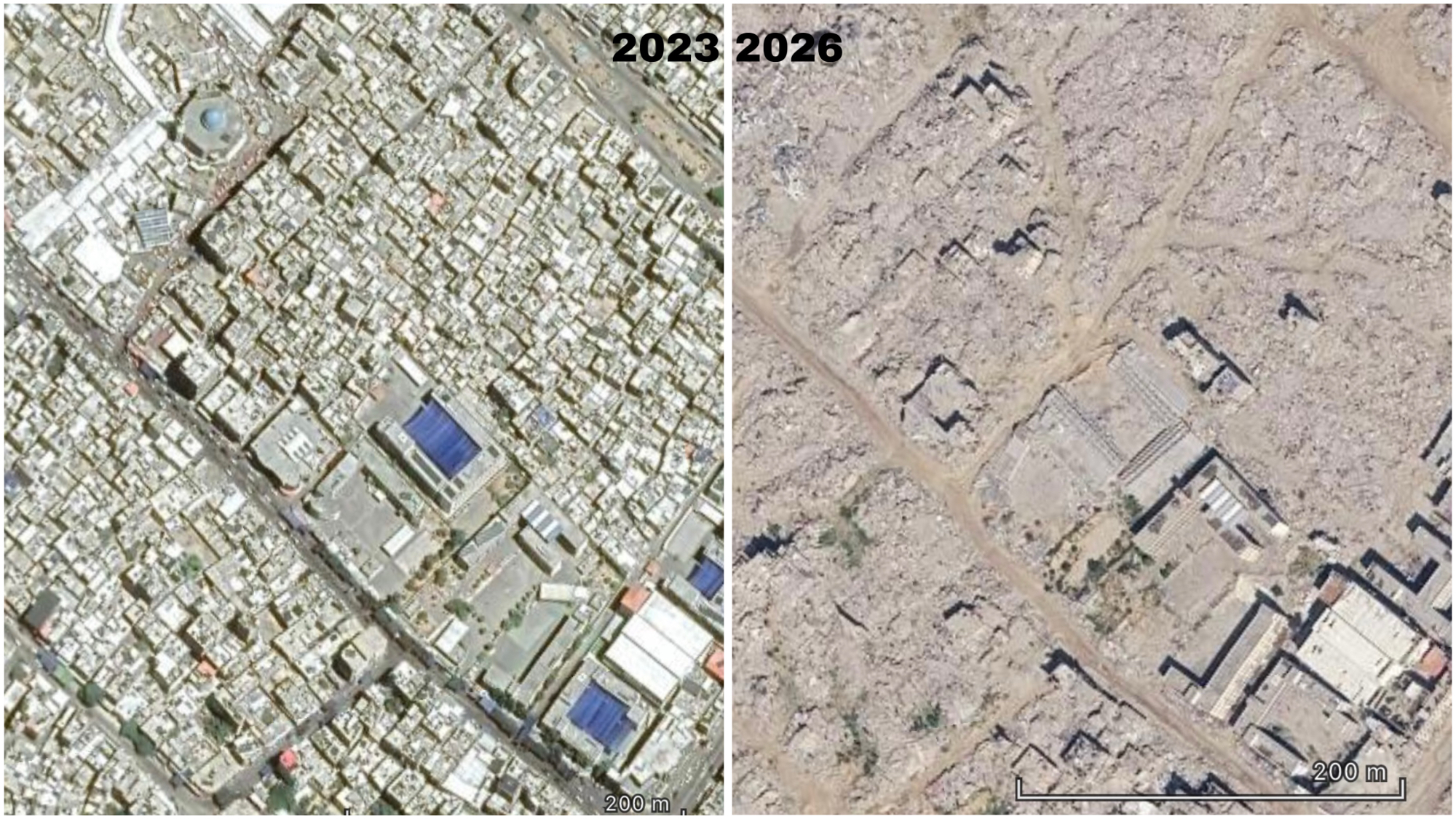
Newly updated satellite imagery on Google Maps and Google Earth is offering a stark visual record of the destruction across parts of the Gaza Strip, showing how densely populated neighbourhoods have been transformed after nearly three years of war.
The imagery follows years in which Gaza was largely represented on Google’s satellite platforms through older images. In 2025, Google began adding imagery showing destruction in northern Gaza, while a further update in 2026 brought newer, higher-resolution imagery covering parts of central and southern Gaza. The latest imagery was captured earlier this year, and became available through Google Earth in May. Reporting later confirmed that updated high-resolution imagery was also available on Google Maps in parts of southern and central Gaza.
A comparison of satellite images from 2023 and 2026 shows the scale of the change. Areas that were once filled with tightly packed residential buildings now appear as expanses of rubble and cleared ground, with roads, individual structures and large sections of neighbourhoods visibly altered or erased. Satellite imagery is not live and may consist of images collected on different dates, but the newly available photographs provide a much clearer picture of Gaza’s physical transformation during the war.
The destruction followed the Israeli military response to the Hamas-led October 7, 2023 retaliatory attacks on southern Israel, which marked the beginning of the ongoing war in Gaza.
The Israeli campaign has since produced enormous destruction and displacement across the Strip. In September 2025, the UN Independent International Commission of Inquiry concluded that Israel had committed genocide in Gaza, citing killings, serious physical and mental harm, the deliberate imposition of conditions of life calculated to bring about the destruction of Palestinians in Gaza, and measures intended to prevent births. The Commission said its findings covered Israeli conduct between October 7, 2023 and July 31, 2025.
The devastation visible today is also connected to a much longer history. During the 1948 war surrounding the establishment of Israel, more than 700,000 Palestinians were displaced from their homes, an event Palestinians refer to as the Nakba, or “catastrophe.” UNRWA says it began operating in 1950 in response to approximately 750,000 Palestine refugees created by the conflict.
Gaza subsequently became home to a large Palestinian refugee population. Following the win of Hamas on Gaza election in 2007, Israel significantly intensified existing restrictions and imposed a land, sea and air blockade. UN humanitarian agencies have described the restrictions as effectively isolating Gaza and leaving much of its population unable to freely access the outside world.
Human Rights Watch has described Gaza under these restrictions as an “open-air prison,” pointing to restrictions on movement that have confined more than two million people to a narrow strip of land and severely limited access to work, education, medical care and family life outside Gaza.
The newly updated satellite imagery therefore does more than provide another view of the war. It allows the physical changes to Gaza to be seen from above: neighbourhoods that existed before October 2023, streets that once connected communities and buildings that formed part of everyday life can now be compared directly with the landscape left after years of bombardment and military operations.