


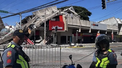
A powerful magnitude 7.8 earthquake struck off the southern coast of the Philippines early Monday morning, causing widespread damage, collapsing buildings, and prompting tsunami alerts across several countries in the Asia-Pacific region.
According to the United States Geological Survey (USGS), the earthquake occurred near the island of Mindanao shortly before 7:40 a.m. local time. The tremor was followed by numerous aftershocks that continued for more than an hour, according to the Philippine Institute of Volcanology and Seismology (PHIVOLCS).
Videos circulating online showed scenes of panic in General Santos City, where a three-storey building housing a Jollibee restaurant collapsed in a massive cloud of dust and debris. Authorities also reported damage to multiple structures across the region, including shattered windows, cracked walls, and partially collapsed roofs.
PHIVOLCS recorded an intensity level of 7 out of 10 in General Santos City, classifying the shaking as “very strong.” Officials are still assessing the full extent of the damage, and casualty figures have not yet been confirmed.
Residents described moments of fear as the earthquake struck. Mary Ann Blanco Rhudy, a nun working at Notre Dame of Dadiangas University, said traffic became chaotic as drivers struggled to maintain control of their vehicles.
“Cars were moving unpredictably, and trees were swaying violently,” she said, adding that several buildings on the university campus sustained structural damage.
Philippine President Ferdinand Marcos Jr. announced that emergency response agencies had been mobilized immediately following the quake. The Office of Civil Defence and the National Disaster Risk Reduction and Management Council were activated to coordinate rescue and relief efforts.
The president urged residents in affected coastal areas to follow evacuation orders and move to higher ground without delay.
Several provinces across Mindanao suspended classes as authorities focused on emergency operations and tsunami preparedness measures.
The Pacific Tsunami Warning Center initially warned that tsunami waves reaching up to three metres could impact parts of the Philippines, while waves of up to one metre were forecast for sections of Indonesia and Malaysia.
Forecasts indicated that the first tsunami waves could reach parts of the Philippines and Indonesia by mid-morning, with potential impacts later extending to southern Japan, Taiwan, Micronesia, Papua New Guinea, and the Solomon Islands.
Although the US National Tsunami Warning Center later revised the earthquake’s magnitude estimate downward from an initial 8.2 to 7.8, officials maintained warnings for several coastal regions across Asia. The agency confirmed that no tsunami threat existed for the continental United States.
Philippine authorities ordered immediate evacuations in several coastal provinces, including Sarangani, Davao Occidental, Sulu, and Tawi-Tawi. Residents were advised to move inland or seek higher ground as a precaution.
Maritime authorities also instructed boat owners to secure vessels and avoid waterfront areas. Fishing boats already at sea were advised to remain in deep waters until conditions were deemed safe.
Indonesia issued similar warnings for vulnerable coastal communities in North Sulawesi, Gorontalo, and the Sangihe Islands, while Japan activated tsunami advisories for Okinawa and other southern island regions.
Although tsunami alerts for Guam and the Northern Mariana Islands were later cancelled, officials warned that strong currents and hazardous coastal conditions could still pose risks to residents and visitors.
Emergency agencies across the region continue to monitor developments as assessments of the earthquake’s impact remain ongoing.